Technical Reports
Drainage Master Plan and Needs Assessment
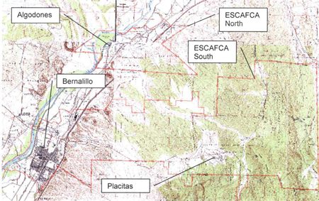
This report is useful to engineers and technically proficient individuals as a reference both for initial drainage conditions within ESCAFCA jurisdictional boundaries and also for planned ESCAFCA projects and improvements in the near term. (May 18, 2008).


Algodones Detention and Conveyance Alt Study
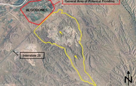
The purpose of completion of this study was to present an analysis of storm collection and conveyance alternatives for the Algodones area that would mitigate flooding impacts to private property, public roadways, and ditches maintained by the Middle Rio Grande Conservancy District due to flows originating from the I-25 right-of-way and large basins upstream of I-25. Based on the available mapping, analysis, and anecdotal information, it is the runoff from these large basins that causes the majority of the flooding problems in the Algodones area. This report provides a conceptual analysis of several detention and conveyance alternatives and includes concept-level cost estimates for each alternative.
Drainage problems in Algodones are due largely to the lack of adequate stormwater conveyance capacity between I-25 and the Rio Grande. Thus, large rainfall events have historically resulted in stormwater damage to private businesses and residences, public roadways, and MRGCD infrastructure. Stormwater originating from the I-25 right-of-way and large drainage basins upstream of I-25 collects in low natural areas before being conveyed across I-25 through existing culverts. Several of these culverts convey significant amounts of runoff. Relatively flat grades and a lack of formalized flow paths between I-25 and the Rio Grande limit the conveyance of stormwater flows through the area. Existing perched irrigation ditches, roads, and railroad embankments further disrupt the flow of stormwater.
Several alternatives are presented in this report to provide detention and conveyance of stormwater runoff originating from I-25 right-of-way and large basins upstream of I-25 to outfall locations near the Rio Grande. The proposed locations of the detention ponds in the three alternatives presented allow flexibility of the system layout to address potential concerns with any particular location.

Athena Pond and Collection
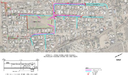
The purpose of this project is to provide a combined surface/underground collection system and temporary retention facility for the area within the Mid-Bernalillo watershed that would mitigate flooding impacts on private property, public roadways, and ditches maintained by the Middle Rio Grande Conservancy District. This project focuses on drainage issues within the Mountain View Estates area.
Drainage problems within the Mid-Bernalillo Watershed, like most of the areas in the ESCAFCA jurisdiction, are due largely to the lack of adequate stormwater conveyance capacity between I-25 and the Rio Grande. Thus, large rainfall events have historically resulted in stormwater damage to private businesses, residences, and public roadways.
Four conveyance systems were analyzed to convey accumulated runoff into the pond. The options were presented to the Board, and one alternative was selected for the final design. Preliminary design and plans are currently under development. Construction of the project is planned for the early summer of 2012.

Mid-Bernalillo Study
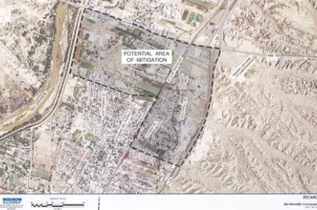
The purpose of this study is to present an analysis of infrastructure options for the Mid-Bernalillo area that would mitigate flooding impacts on private property, public roadways, and ditches maintained by the Middle Rio Grande Conservancy District (MRGCD) due to runoff originating from large basins upstream (east) of I-25. This study focuses on the middle portion of Bernalillo, south of US 550 and north of Calle Don Francisco. It has been determined that mitigating runoff from upstream watersheds and providing an outfall to the Rio Grande are key to alleviating flooding issues in the Mid-Bernalillo area.
Prior to 1890, runoff from the Sandia Mountains was conveyed through the Town of Bernalillo in several ditches (desagues) draining east to west to the Rio Grande. With the construction of the railroad and development within the town, the paths of these ditches were interrupted. Construction of U.S. Highway 66/85 (which later became Interstate 25) further interrupted natural flow patterns. Drainage crossing structures under the railroad and highway both have forced concentrate flows. So, the construction of these major north-south transportation and irrigation facilities, along with the attendant development of the Town with homes, businesses, and streets, have resulted in stormwater runoff spreading out through the Town and causing significant damage throughout the last century.
The most northern basin, approximately 4.1 square miles, is controlled by the Piedra Liza Dam. However, since no apparent outlet to the Rio Grande exists, the quantity of collected runoff discharged from the dam could potentially inundate the Town for four consecutive days.
The most significant problems recorded in recent storm events occurred in the residential areas between the railroad tracks and the Sandia Acequia maintained by the MRGCD. Sediment deposition along South Hill Road caused road closures. Larger events breach the Sandia Acequia banks, causing them to fail and flood the residential areas between it and the railroad.
Collection and conveyance options are currently being studied.

Mitigation Exhibit PDF (4 MB)
ESCAFCA Voting Districts Map (2 M.B.)
MRGCD Town of Bernalillo Profile by BHI (17 M.B.)
